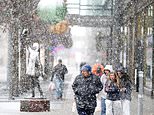
A powerful bomb cyclone is poised to impact millions of Americans, bringing severe winter weather across the Great Lakes and Northeast. As of December 29, 2025, meteorologists have issued winter weather alerts, forecasting snow accumulations of up to two feet in some areas, particularly in the Great Lakes region, New York, New Hampshire, and Maine.
A bomb cyclone, or bombogenesis, occurs when a low-pressure system rapidly intensifies, leading to extreme weather conditions. According to the National Weather Service (NWS), over 30 million people are currently under winter weather alerts. The storm is expected to create hazardous travel conditions, particularly as colder air moves in, transforming brief wintry mixes into heavy snowfall and whiteout conditions.
Storm Path and Impacts
Meteorologists from AccuWeather predict that the storm will strengthen significantly as it moves through the Midwest and Great Lakes. Areas such as Green Bay, Chicago, Detroit, Indianapolis, Pittsburgh, Washington, D.C., Philadelphia, New York City, and Boston are directly in the storm’s path. Forecasts indicate that these locations could receive between six and ten inches of snow by December 30, with isolated regions potentially experiencing even higher totals.
Brandon Buckingham, an AccuWeather meteorologist, stated, “The storm will bring risks of heavy snow, ice, severe thunderstorms, powerful wind gusts, and heavy rain.” The system has already impacted the Midwest, leaving over 100,000 residents without power due to heavy snow and strong winds. This storm is linked to the recent rainfall and flooding that affected California on Christmas Eve and Christmas Day.
Wind gusts are anticipated to reach at least 35 miles per hour in areas from southwestern Minnesota to central Ontario. Such high winds, combined with snowfall, could reduce visibility to less than one-quarter mile for extended periods, meeting blizzard criteria. Buckingham emphasized that these conditions will make travel extremely difficult and potentially dangerous.
Warnings and Preparedness
Wind advisories are currently in effect from the Ohio Valley to the Northeast, with gusts predicted to reach as high as 55 miles per hour. An estimated 114 million people across the eastern United States are under high wind alerts, as reported by CBS News. Cities like Bangor and Portland in Maine, Albany and Binghamton in New York, Scranton in Pennsylvania, and Burlington in Vermont may experience light freezing rain late Sunday into Monday, creating treacherous travel conditions.
AccuWeather has highlighted that the rapid pressure changes associated with a bomb cyclone will generate strong winds even in regions not experiencing precipitation. Gusts of 40 to 60 miles per hour are expected, potentially disrupting air travel at major airports such as Chicago-O’Hare and those in the New York City area from Monday night into Tuesday morning.
As this powerful winter storm approaches, residents in affected areas are urged to remain vigilant and prepare for potentially severe weather conditions. The combination of heavy snowfall, high winds, and icy roads poses significant risks to travel and safety.